Snow has been low but there’s more to come, say scientists
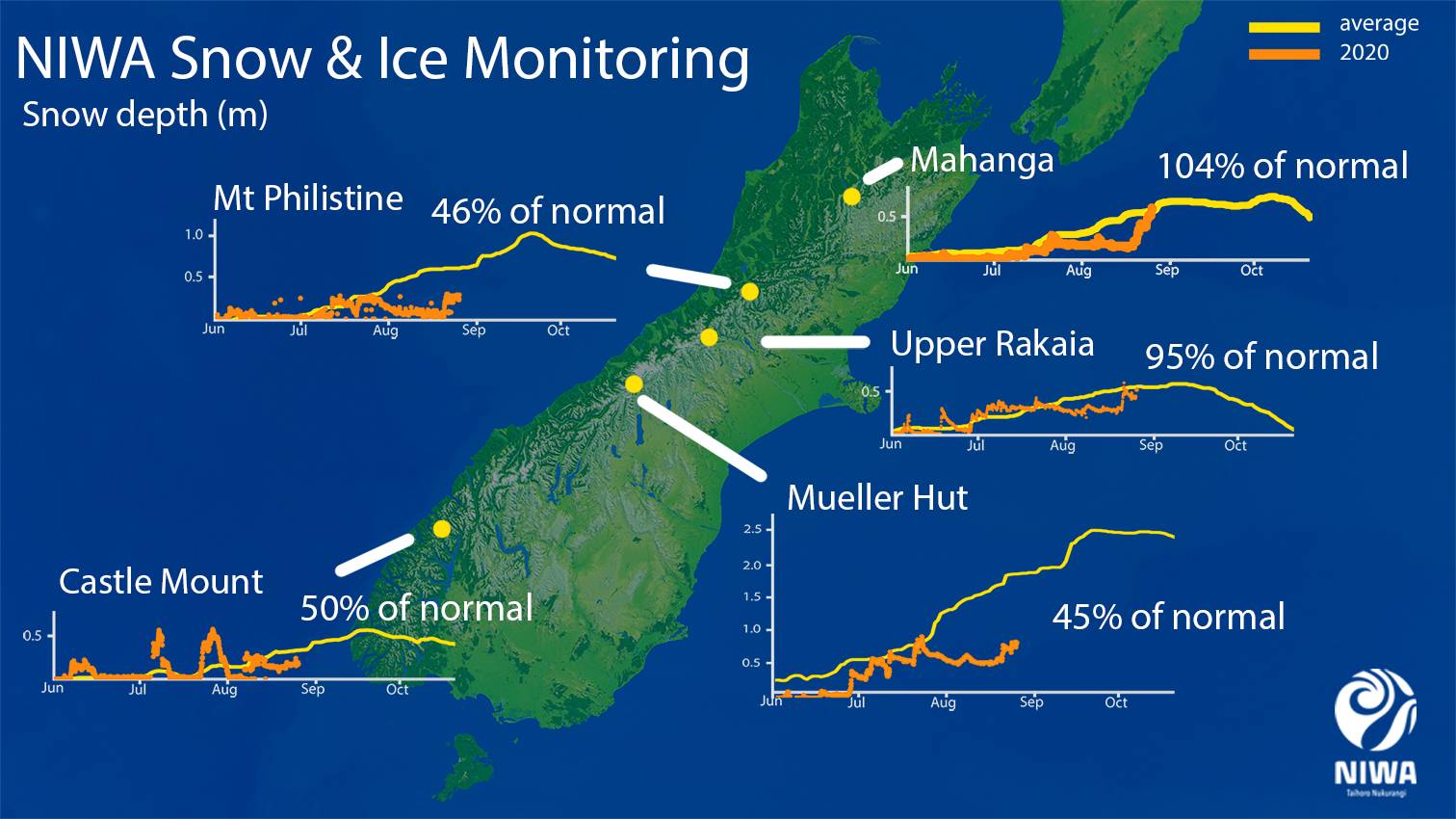
NIWA’s South Island snow and ice monitoring stations have confirmed what many skiers have been talking about: winter has been dry and snow coverage has been poor. In fact several sites have recorded half their typical snow depth for this time of year.
But there is hope. Locked down Aucklanders forced into delaying winter ski holidays trips to the South Island until next week can take heart: new snow has fallen this week and more flurries are expected over the next few days.
Snow experts Drs Christian Zammit and Jono Conway say the 11 stations at which NIWA measures weather and snow experienced very little snowfall between the last week of July until this week.

“The early part of the season was fairly typical, but then it dried up. Cold temperatures in early August were ideal for snow making but there was no rain during that time to make it happen.”
In fact it has been a dry winter for the most of the South Island, particularly in Canterbury and coastal Otago. Timaru and Oamaru have only seen half their typical winter rainfall. Mt Cook is on track to have its second driest winter since records began in 1928.
Drs Zammit and Conway say while most of NIWA’s snow monitoring stations have had less snow than usual, the Arthurs Pass site on Mt Philistine has had the least.
They say there is often a hiatus in snowfall during mid-winter when large high-pressure systems cover the South Island that produce settled weather. “This often occurs around late July, but this year seems to have been longer and stronger than usual.”
However, it is important to note that snow depth varies greatly with terrain and the location specific snow monitoring sites make it difficult to extrapolate this information across a larger area.
The extremely variable nature of snow from year to year can also mask the effects of long-term change.
Overall, Drs Zammit and Conway say warmer winter temperatures in future are expected to cause more precipitation to fall as rain and not snow, especially at mid and low elevations. This will decrease the length of time that snow covers the ground and it is expected that the historical snowline will rise with climate change.
“At higher elevations, changes in the total amount of precipitation may result in increases or decreases in snowfall depending on whether a region is getting wetter or drier. Again, because of the large year-to-year variability we are likely to see years with lots of snow and years with very little.”
Meanwhile, NIWA forecaster Nava Fedaeff says despite the days getting longer, winter still has more to give. “Chilly southwesterlies at the start of the week have already brought new snow to South Island slopes and more flurries are coming – particularly on Saturday and Monday.”
She says this year’s winter is likely to be one of the three top warmest on record due to frequent high pressure, more northeasterly winds than normal and much warmer than usual sea temperatures around our coastlines.
NIWA will release its latest seasonal climate outlook for the next three months tomorrow, and its winter climate summary next week.